Public record · 14-day delayAbout our data
4929 Buford Highway Northeast, Norcross, GA 30071 · Gwinnett County
Cancelled · Was scheduled for June 2, 2026
Subscribers get the latest updates, owner information including mailing address, tax card links, and the option to create instant property alerts.
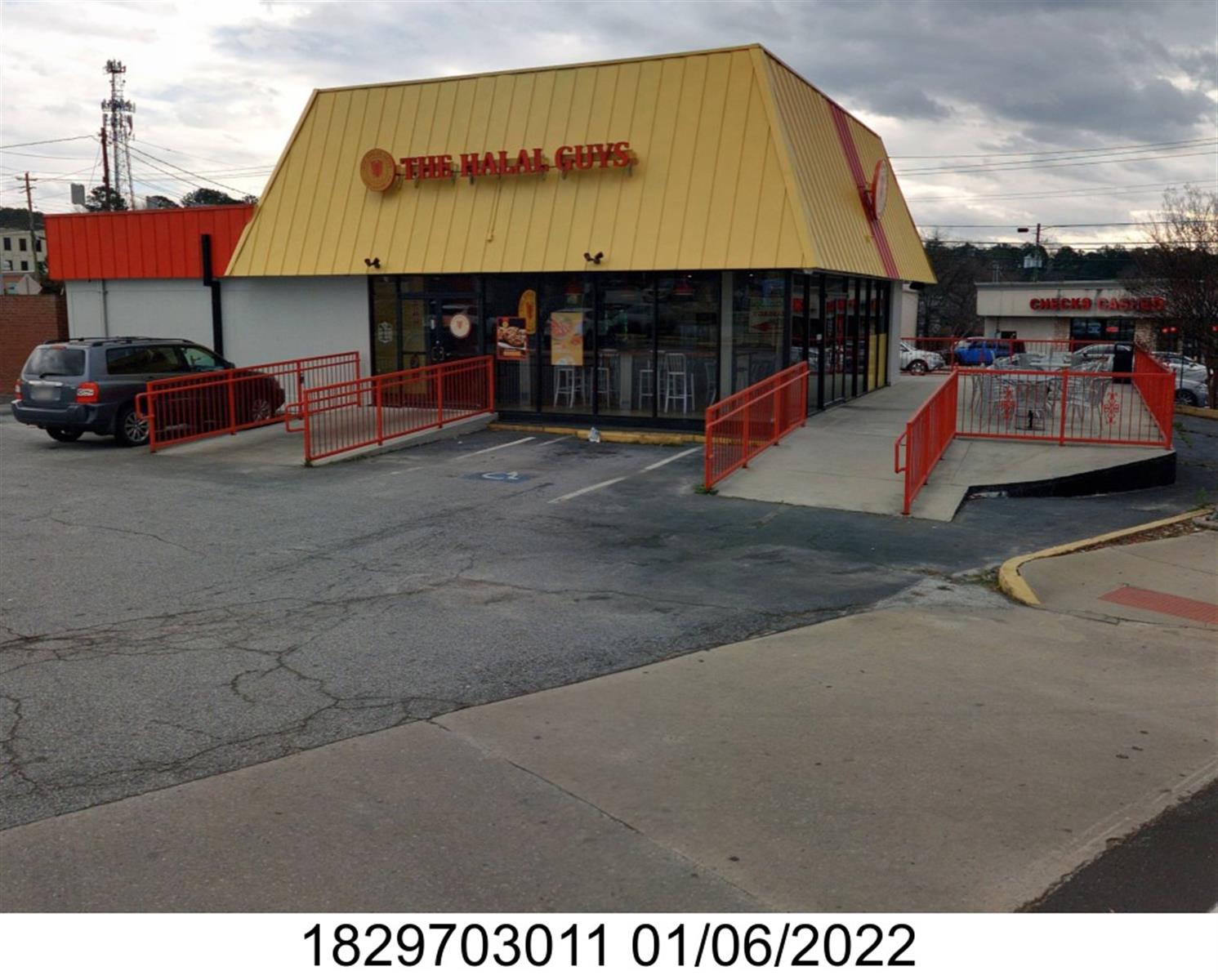
Loading Street View...
For this property only. Prepared by our title team and emailed to you.
An illustrative scenario from your assumptions, not an estimate for this property.
Profit as a percentage of the total cost of the deal, earned over the 180-day hold. Not a yearly rate.
Example values, not estimates for this property.
Maximum bid for this scenario
$165,183
The highest bid that still returns 20% on all-in cost under the assumptions below. Higher repairs or a higher target lower it.
Demonstration values, not typical costs or this property's. Subscribers set their own in the full worksheet.
430-507539 5/7,5/14,5/21,5/28NOTICE OF SALE UNDER POWER IN SECURITY DEEDSTATE OF GEORGIACOUNTY OF DEKALB Under and by virtue of the Power of Sale contained in the Deed to Secure Debt, Assignment of Lease and Rents, Security Agreement and Fixture Filing from NY ENTERPRISE INTERNATIONAL LLC, a Georgia limited liability company to URBAN HOLDINGS, LLC, a Delaware limited liability company, dated January 29, 2026 and recorded in Deed Book 32438, Page 758, in the offices of the Clerk of the Superior Court of DeKalb County, Georgia (as same may have been modified from time to time, collectively the “Security Deed”), the undersigned will sell at public outcry to the highest and best bidder for cash before the door of the Courthouse of DeKalb County, Georgia, during the legal hours of sale, on the first Tuesday in June, 2026, the following described real property, to wit:ALL THAT TRACT OR PARCEL OF LAND LYING AND BEING IN LAND LOT 297 OF THE 18TH DISTRICT, DEKALB COUNTY, GEORGIA, CITY OF CHAMBLEE, KNOWN AS 2494 CHAMBLEE TUCKER ROAD AND MORE PARTICULARLY DESCRIBED AS FOLLOWS: COMMENCING AT A CONCRETE MONUMENT FOUND ON THE MITERED NORTHEAST INTERSECTION OF BUFORD HIGHWAY (A/K/A U.S. HIGHWAY 23 OR GA HIGHWAY 13) (100' RIGHT OF WAY) AND CHAMBLEE TUCKER ROAD (VARIABLE RIGHT OF WAY), THENCE SOUTH 28 DEGREES 00 MINUTES 23 SECONDS EAST A DISTANCE OF 30.81 FEET TO A CONCRETE MONUMENT FOUND, THENCE ALONG THE NORTHERN RIGHT OF WAY OF CHAMBLEE TUCKER ROAD SOUTH 89 DEGREES 48 MINUTES 58 SECONDS EAST A DISTANCE OF 177.07 FEET TO A ½" REBAR FOUND, THENCE CONTINUING ALONG SAID RIGHT OF WAY SOUTH 89 DEGREES 42 MINUTES 49 SECONDS EAST A DISTANCE OF 76.36 FEET TO A NAIL SET IN A WALL AND THE TRUE POINT OF BEGINNING. FROM SAID TRUE POINT OF BEGINNING AND LEAVING SAID RIGHT OF WAY, THENCE NORTH 03 DEGREES 36 MINUTES 13 SECONDS EAST A DISTANCE OF 184.82 FEET TO A NAIL SET IN A WALL, THENCE SOUTH 89 DEGREES 09 MINUTES 17 SECONDS EAST A DISTANCE OF 110.28 FEET TO A NAIL FOUND, THENCE SOUTH 00 DEGREES 46 MINUTES 26 SECONDS WEST A DISTANCE OF 183.22 FEET TO A ½" REBAR FOUND ON THE NORTHERN RIGHT OF WAY OF CHAMBLEE TUCKER ROAD, THENCE ALONG SAID RIGHT OF WAY NORTH 89 DEGREES 49 MINUTES 15 SECONDS WEST A DISTANCE OF 119.41 FEET TO A NAIL SET IN A WALL AND THE TRUE POINT OF BEGINNING. SAID TRACT HAVING AN AREA OF 21,117.6 SQ. FT., 0.485 ACRES, AS SHOWN ON SURVEY BY GEORGIA LAND SURVEYING CO., BEARING THE SEAL AND CERTIFICATION OF JOSH L. LEWIS IV, GEORGIA REGISTERED LAND SURVEYOR NO. 3028, DATED JULY11, 2017, AND BEING REFERENCED AS JOB NUMBER 197822. TOGETHER WITH: ALL THAT TRACT OR PARCEL OF LAND LYING AND BEING IN LAND LOT 297 OF THE 18TH DISTRICT, DEKALB COUNTY, GEORGIA, CITY OF CHAMBLEE, KNOWN AS 2512 CHAMBLEE TUCKER ROAD AND MORE PARTICULARLY DESCRIBED AS FOLLOWS: BEGINNING AT A CONCRETE MONUMENT FOUND ON THE MITERED NORTHWEST INTERSECTION OF SHALLOWFORD ROAD (VARIABLE RIGHT OF WAY) AND CHAMBLEE TUCKER ROAD (VARIABLE RIGHT OF WAY), THENCE SOUTH 42 DEGREES 10 MINUTES 57 SECONDS WEST A DISTANCE OF 34.87 FEET TO A CONCRETE MONUMENT FOUND, THENCE ALONG THE NORTHERN RIGHT OF WAY OF CHAMBLEE TUCKER ROAD NORTH 89 DEGREES 40 MINUTES 13 SECONDS WEST A DISTANCE OF 108.05 FEET TO A HOLE FOUND CHISELED IN A DIVIDING WALL, THENCE LEAVING SAID RIGHT OF WAY NORTH 00 DEGREES 41 MINUTES 43 SECONDS EAST A DISTANCE OF 182.87 FEET TO A 1/2" REBAR FOUND, THENCE SOUTH 89 DEGREES 35 MINUTES 05 SECONDS EAST A DISTANCE OF 105.82 FEET TO A 1" CRIMP TOP PIPE FOUND (BENT) ON THE WESTERN RIGHT OF WAY OF SHALLOWFORD ROAD, THENCE ALONG SAID RIGHT OF WAY SOUTH 08 DEGREES 29 MINUTES 42 SECONDS EAST A DISTANCE OF 158.61 FEET TO A CONCRETE MONUMENT FOUND AND THE TRUE POINT OF BEGINNING. SAID TRACT HAVING AN AREA OF 21,685.1 SQ. FEET, 0.498 ACRES, AS SHOWN ON SURVEY BY GEORGIA LAND SURVEYING CO., BEARING THE SEAL AND CERTIFICATION OF JOSH L. LEWIS IV, GEORGIA REGISTERED LAND SURVEYOR NO. 3028, DATED JULY 11, 2017, AND BEING REFERENCED AS JOB NUMBER 197821. FURTHER TOGETHER WITH: ALL THAT TRACT OR PARCEL OF LAND LYING AND BEING IN LAND LOT 297 OF THE 18TH DISTRICT, DEKALB COUNTY, GEORGIA, CITY OF CHAMBLEE, KNOWN AS 4929 BUFORD HIGHWAY (INCLUDING 4937 BUFORD HIGHWAY AND 2480 CHAMBLEE TUCKER ROAD) AND MORE PARTICULARLY DESCRIBED AS FOLLOWS: BEGINNING AT A CONCRETE MONUMENT FOUND ON THE MITERED NORTHEAST INTERSECTION OF BUFORD HIGHWAY (A/K/A U.S. HIGHWAY 23 OR GA HIGHWAY 13) (100' RIGHT OF WAY) AND CHAMBLEE TUCKER ROAD (VARIABLE RIGHT OF WAY), THENCE ALONG SAID EASTERN RIGHT OF WAY OF BUFORD HIGHWAY NORTH 24 DEGREES 53 MINUTES 27 SECONDS EAST A DISTANCE OF 175.42 FEET TO A ½" REBAR FOUND, THENCE LEAVING SAID RIGHT OF WAY SOUTH 89 DEGREES 22 MINUTES 52 SECONDS EAST A DISTANCE OF 129.32 FEET TO A NAIL SET IN A WALL, THENCE SOUTH 03 DEGREES 34 MINUTES 55 SECONDS WEST A DISTANCE OF 185.86 FEET TO A ½" REBAR FOUND ON THE NORTHERN RIGHT OF WAY OF CHAMBLEE TUCKER ROAD, THENCE ALONG SAID RIGHT OF WAY NORTH 89 DEGREES 48 MINUTES 58 SECONDS WEST A DISTANCE OF 177.07 FEET TO A CONCRETE MONUMENT FOUND, THENCE NORTH 28 DEGREES 00 MINUTES 23 SECONDS WEST A DISTANCE OF 30.81 FEET TO A CONCRETE MONUMENT FOUND AND THE TRUE POINT OF BEGINNING. SAID TRACT HAVING AN AREA OF 30,669.7 SQ. FT., 0.704 ACRES, AS SHOWN ON SURVEY BY GEORGIA LAND SURVEYING CO., BEARING THE SEAL AND CERTIFICATION OF JOSH L. LEWIS IV, GEORGIA REGISTERED LAND SURVEYOR NO. 3028, DATED JULY 11, 2017, AND BEING REFERENCED AS JOB NUMBER 197823. PROPERTY BEING MORE COMMONLY KNOWN AS:(i) 4929 Buford Highway, Chamblee, DeKalb Co., Georgia 30341 [Tax Parcel ID #18 297 03 011](ii) 2494 Chamblee Tucker Road, Chamblee, DeKalb Co., Georgia 30341 [Tax Parcel ID #18 297 03 013(iii) 2512 Chamblee Tucker Road, Chamblee, DeKalb Co., Georgia 30341 [Tax Parcel ID #18 297 03 017](iv) 4937 Buford Highway, Chamblee, DeKalb Co., Georgia 30341 [Tax Parcel ID #18 297 03 032(v) 2480 Chamblee Tucker Road, Chamblee, DeKalb Co., Georgia 30341 [Tax Parcel ID #18 297 03 036]The debt secured by the Security Deed is evidenced by a Real Estate Note, dated January 29, 2026, from NY ENTERPRISE INTERNATIONAL LLC, a Georgia limited liability company to URBAN HOLDINGS, LLC, a Delaware limited liability company, in the original principal amount of $1,384,500.00 (as same may have been further modified, renewed or amended, collectively the “Note”); plus interest from date on the unpaid balance until paid, and other indebtedness.Default has occurred and continues under the terms of the Note and Security Deed by reason of, among other possible events of default, the nonpayment when due of the indebtedness evidenced by the Note and secured by the Security Deed and the failure to comply with the terms and conditions of the Note and Security Deed. By reason of this default, the Security Deed has been declared foreclosable according to its terms.The above-described real property will be sold to the highest and best bidder for cash as the property of NY ENTERPRISE INTERNATIONAL LLC, the proceeds to be applied to the payment of said indebtedness, attorneys' fees, and the lawful expenses of said sale, all as provided in the Note and Security Deed. The sale shall be subject to the following: all outstanding ad valorem taxes and/or assessments, if any; possible redemptive rights of the Internal Revenue Service, if any; and all prior assessments, easements, restrictions or matters of record.To the best of the undersigned's knowledge and belief, the real property is presently owned by NY ENTERPRISE INTERNATIONAL LLC.To the best of the undersigned's knowledge and belief, the party in possession of the real property is NY ENTERPRISE INTERNATIONAL LLC, and tenants holding under them.URBAN HOLDINGS, LLC, as Attorney-in-Fact for ++NY ENTERPRISE INTERNATIONAL LLC++.M. Todd Westfall, EsquireWESTFALL, LLC4994 Lower Roswell Rd, Ste 6Marietta, Georgia 30068(678) 384-7005
Recorded from 1 source. First recorded May 7, 2026. Record as of October 24, 2026. About this data & licence
Subscribers see this record 14 days earlier, plus the owner of record and mailing address.
Title Reports need only a free account.