Public record · 14-day delayAbout our data
583 Dollar Rd, Dawsonville, GA 30534-2030 · Dawson County
Cancelled · Was scheduled for July 7, 2026
Subscribers get the latest updates, owner information including mailing address, tax card links, and the option to create instant property alerts.
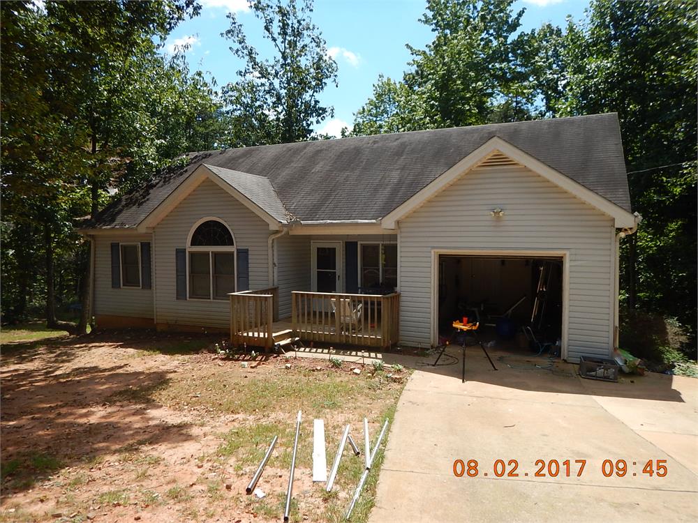
Loading Street View...
For this property only. Prepared by our title team and emailed to you.
An illustrative scenario from your assumptions, not an estimate for this property.
Profit as a percentage of the total cost of the deal, earned over the 180-day hold. Not a yearly rate.
Example values, not estimates for this property.
Maximum bid for this scenario
$165,183
The highest bid that still returns 20% on all-in cost under the assumptions below. Higher repairs or a higher target lower it.
Demonstration values, not typical costs or this property's. Subscribers set their own in the full worksheet.
Foreclosures DERRICK CHARLES DEITRICH AND TARA LYNN MANSPEAKER STATE OF GEORGIA COUNTY OF DAWSON NOTICE OF SALE UNDER POWER Pursuant to the power of sale contained in the Security Deed executed by DERRICK CHARLES DEITRICH AND TARA LYNN MANSPEAKER to MENNA COMPANY, INC. DBA INDEPENDENT MORTGAGE ASSOCIATES in the original principal amount of $126,350.00 dated May 29, 2004, and recorded in Deed Book 603, Page 68, Dawson County records, said Security Deed being last transferred to FEDERAL HOME LOAN MORTGAGE CORPORATION, AS TRUSTEE FOR FREDDIE MAC SLST 2025-2 PARTICIPATION INTEREST TRUST in Deed Book 01819, Page 0230, Dawson County records, the undersigned will sell at public outcry to the highest bidder for cash, before the Courthouse door in said County, or at such other place as lawfully designated, within the legal hours of sale, on 7/7/2026, the property in said Security Deed and described as follows: ALL THAT TRACT OR PARCEL OF LAND LYING AND BEING IN LAND LOT 979 OF THE 5TH DISTRICT, 1ST SECTION, DAWSON COUNTY, GEORGIA, BEING MORE PARTICULARLY DESCRIBED AS FOLLOWS: TO ARRIVE AT THE TRUE POINT OF BEGINNING, BEGINNING AT A POINT ON THE SOUTHERLY RIGHT OF WAY LINE OF DOLLAR ROAD (A 40 FOOT RIGHT OF WAY) WHICH POINT IS SOUTH 01 DEGREE 14 MINUTES 18 SECONDS WEST, 127.11 FEET FROM THE POINT OF INTERSECION OF LAND LOTS 927, 926, 978, AND 979 AS MEASURED ALONG THE LAND LOT LINE DIVIDING LAND LOTS 978 AND 979; RUNNING THENCE SOUTH 86 DEGREES 05 MINUTES 29 SECONDS EAST, 149.96 FEET TO A POINT WHICH IS THE TRUE POINT OF BEGINNING; FROM THE TRUE POINT OF BEGINNING THUS ESTABLISHED, RUNNING THENCE SOUTH 86 DEGREES 05 MINUTES 29 SECONDS EAST, 22.20 FEET TO A POINT AS MEASURED ALONG THE SOUTHERLY RIGHT OF WAY LINE OF DOLLAR ROAD ( A 40 FOOT RIGHT OF WAY); RUNNING THENCE SOUTH 80 DEGREES 16 MINUTES 09 SECONDS EAST, 87.75 FEET TO A POINT; RUNNING THENCE SOUTH 72 DEGREES 07 MINUTES 24 SECONDS EAST, 40.00 FEET TO A POINT; RUNNING THENCE SOUTH 14 DEGREES 40 MINUTES 54 SECONDS WEST, 543.61 FEET TO A POINT; RUNNING THENCE SOUTH 89 DEGREES 26 MINUTES 09 SECONDS WEST, 87.80 FEET TO A POINT; RUNNING THENCE NORTH 08 DEGREES 04 MINUTES 55 SECODNS EAST, 560.92 FEET TO A POINT WHICH POINT IS THE TRUE POINT OF BEGINNING AS SHOWN ON PLAT OF SURVEY FOR SHELBREN INVESTMENTS, INC., PREPARED BY RICHARD WEBB & ASSOCIATES, RICHARD J. WEBB, SURVEYOR GA RLS #2507, DATED AUGUST 1, 1996 AND CONTAINING 1.500 ACRES. Said property being known as: 583 DOLLAR ROAD, DAWSONVILLE, GA 30534 To the best of the undersigned's knowledge, the party or parties in possession of said property is/are DERRICK CHARLES DEITRICH AND TARA LYNN MANSPEAKER or tenant(s). The debt secured by said Security Deed has been and is hereby declared due and payable because of, among other possible events of default, failure to pay the indebtedness as provided for in the Note and said Security Deed. The debt remaining in default, this sale will be made for the purpose of paying the same and all expenses of sale, including attorney's fees (notice of intent to collect attorney's fees having been given). Said property will be sold subject to the following: (1) any outstanding ad valorem taxes (including taxes which are a lien, whether or not yet due and payable); (2) the right of redemption of any taxing authority; (3) any matters which might be disclosed by an accurate survey and inspection of the property; and (4) any assessments, liens, encumbrances, zoning ordinances, restrictions, covenants, and matters of record superior to the Security Deed first set out above. Said sale will be conducted subject to the following: (1) confirmation that the sale is not prohibited under the U.S. Bankruptcy Code; and (2) final confirmation and audit of the status of the loan with the holder of the Security Deed. The name, address, and telephone number of the individual or entity who has full authority to negotiate, amend, and modify all terms of the mortgage is as follows: Selene Finance LP 3501 Olympus Boulevard, 5th Floor, Suite 500 Dallas, TX 75019 877-768-3759 Note that pursuant to O.C.G.A. SS 44-14-162.2, the above individual or entity is not required by law to negotiate, amend, or modify the terms of the mortgage. THIS LAW FIRM IS ACTING AS A DEBT COLLECTOR ATTEMPTING TO COLLECT A DEBT. ANY INFORMATION OBTAINED MAY BE USED FOR THAT PURPOSE. FEDERAL HOME LOAN MORTGAGE CORPORATION, AS TRUSTEE FOR FREDDIE MAC SLST 2025-2 PARTICIPATION INTEREST TRUST, as Attorney-in-Fact for DERRICK CHARLES DEITRICH AND TARA LYNN MANSPEAKER Robertson, Anschutz, Schneid, Crane & Partners, PLLC 13010 Morris Rd., Suite 450 Alpharetta, GA 30004 Phone: 470-321-7112 Firm File No. 26-397258 160303 6/3,10,17,24
Recorded from 2 sources. First recorded May 13, 2026. Record as of October 26, 2026. About this data & licence
Subscribers see this record 14 days earlier, plus the owner of record and mailing address.
Title Reports need only a free account.