Public record · 14-day delayAbout our data
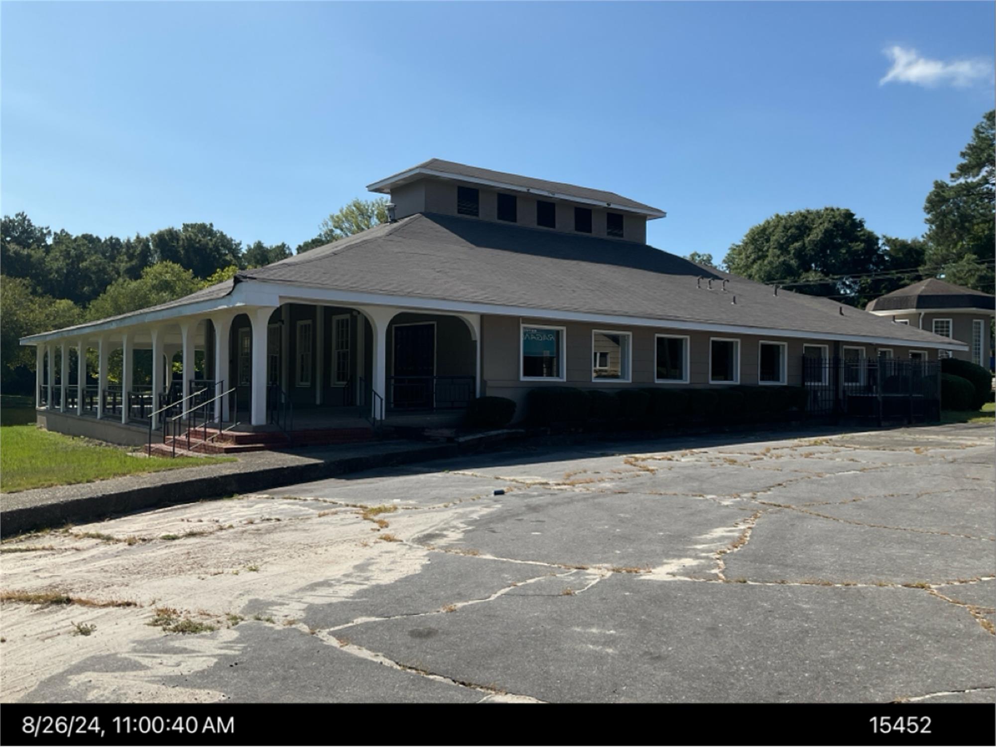
And Masseyville Rd, Bibb, GA 31217 · Bibb County
No outcome reported · Sale date June 2, 2026 · no outcome reported
Subscribers get the latest updates, owner information including mailing address, tax card links, and the option to create instant property alerts.
For this property only. Prepared by our title team and emailed to you.
An illustrative scenario from your assumptions, not an estimate for this property.
Profit as a percentage of the total cost of the deal, earned over the 180-day hold. Not a yearly rate.
Example values, not estimates for this property.
Maximum bid for this scenario
$165,183
The highest bid that still returns 20% on all-in cost under the assumptions below. Higher repairs or a higher target lower it.
Demonstration values, not typical costs or this property's. Subscribers set their own in the full worksheet.
AO 664 STATE OF GEORGIA COUNTY OF BIBB NOTICE OF SALE UNDER POWER COMPUTERSHARE TRUST COMPANY, NATIONAL ASSOCIATION, AS TRUSTEE, ON BEHALF OF THE REGISTERED HOLDERS OF BMO 2023-C7 MORTGAGE TRUST, COMMERCIAL MORTGAGE PASS -THROUGH CERTIFICATES, SERIES 2023-C7 AND THE UNCERTIFICATED INTEREST OWNERS (Lender), under and by virtue of the power of sale contained in that certain Deed to Secure Debt, Assignment of Leases and Rents, Security Agreement and Fixture Filing dated as of November 17, 2023, and recorded on November 20, 2023, in Book 11732, Page 365 in the real estate records of Bibb County, Georgia (as amended from time to time, the Security Instrument), executed and delivered by TEP RAGAN DE, LLC, a Delaware limited liability company (Borrower), to UBS AG, by and through its BRANCH OFFICE AT 1285 AVENUE OF THE AMERICAS, NEW YORK, NEW YORK, a U.S. branch of a Swiss banking corporation (Original Lender), as assigned by Original Lender to Lender, pursuant to that certain Assignment of Deed to Secure Debt, Assignment of Leases and Rents, Security Agreement and Fixture Filing dated as of December 22, 2023, and recorded on March 18, 2024, in Deed Book 11817, Page 146 in the real estate records of Bibb County, Georgia (the Assignment, and together with the Security Instrument, the Security Deed), which Security Deed secures indebtedness evidenced by that certain Promissory Note dated November 17, 2023, in the original principal amount of $33,000,000.00, executed by Borrower in favor of Original Lender (the Note). Lender, being the owner and holder of the Security Deed and acting in its capacity as attorney-in-fact for Borrower, will sell at public outcry to the highest bidder for cash before the Courthouse door of Bibb County, Georgia, within the legal hours of sale on June 2, 2026, certain real property legally described as (or so much thereof as has not, as of the first Tuesday, been released by duly recorded instrument from the Security Deed): PARCEL 1 All that tract or parcel of land lying and being in Land Lots 82 and 101, 7th Land District being further described in Plat Book 87, Page 506, of Bibb County, Georgia records, being more particularly described as follows: BEGINNING AT THE INTERSECTION OF THE NORTH RIGHT-OF-WAY OF MASSEYVILLE ROAD AND THE EAST RIGHT-OF-WAY OF THE WESTERN MOST PORTION OF LAKESHORE DRIVE THENCE N 21 05 16 E A DISTANCE OF 781.47 ALONG THE EASTERLY RIGHT-OF-WAY OF LAKESHORE DRIVE TO AN IRON PIN; THENCE N 20 59 14 E A DISTANCE OF 71.82 TO AN IRON PIN; THENCE N 05 50 57 E A DISTANCE OF 55.73 TO AN IRON PIN AT THE POINT OF BEGINNING; THENCE N 20 29 33 W A DISTANCE OF 55.94; THENCE N 39 00 37 W A DISTANCE OF 61.32; THENCE N 47 36 51 W A DISTANCE OF 77.82; THENCE N 58 10 52 W A DISTANCE OF 81.60; THENCE N 66 21 59 W A DISTANCE OF 59.00; THENCE N 86 20 56 W A DISTANCE OF 67.46; THENCE N 80 48 28 W A DISTANCE OF 114.25; THENCE N 42 24 55 W A DISTANCE OF 21.39; THENCE N 17 49 40 W A DISTANCE OF 94.43; THENCE N 45 13 07 E A CHORD DISTANCE OF 132.45 AND ALONG AN ARC TO THE RIGHT A DISTANCE OF 163.50; THENCE S 71 44 06 E A DISTANCE OF 76.71; THENCE S 88 57 00 E A CHORD DISTANCE OF 228.05 AND ALONG AN ARC TO THE LEFT A DISTANCE OF 231.51; THENCE N 73 50 05 E A DISTANCE OF 62.64; THENCE N 61 23 40 E A CHORD DISTANCE OF 81.56 AND ALONG AN ARC TO THE LEFT A DISTANCE OF 82.21; THENCE N 26 28 02 E A CHORD DISTANCE OF 144.79 AND ALONG AN ARC TO THE LEFT A DISTANCE OF 148.58 ALONG THE EASTERLY RIGHT-OF-WAY OF LAKESHORE DRIVE; THENCE N 03 58 55 E A DISTANCE OF 118.37 TO AN IRON PIN ON THE EASTERLY RIGHT-OF-WAY OF LAKESHORE DRIVE; THENCE N 1526 28 E A CHORD DISTANCE OF 88.41 AND ALONG AN ARC TO THE RIGHT A DISTANCE OF 89.00 TO AN IRON PIN; THENCE N 26 53 53 E A DISTANCE OF 1.61 TO AN IRON PIN; THENCE S 63 13 29 E A DISTANCE OF 185.88 TO AN IRON PIN; THENCE N 26 46 29 E A DISTANCE OF 140.00 TO AN IRON PIN; THENCE N 58 58 25 W A DISTANCE OF 69.79 TO AN IRON PIN ON THE SOUTHERLY RIGHT-OF-WAY OF LAKESHORE DRIVE; THENCE N 66 38 31 E A DISTANCE OF 63.20; THENCE N 73 53 31 E A DISTANCE OF 52.70; THENCE N 87 24 31 E A DISTANCE OF 63.80; THENCE S 68 44 29 E A DISTANCE OF 46.50; THENCE S 45 20 29 E A DISTANCE OF 45.60; THENCE S 38 29 29 E A DISTANCE OF 85.00; THENCE S 32 18 29 E A DISTANCE OF 78.80; THENCE S 24 44 29 E A DISTANCE OF 59.70; THENCE S 17 19 29 E A DISTANCE OF 52.80; THENCE S 08 00 29 E A DISTANCE OF 36.00; THENCE S 03 17 47 W A DISTANCE OF 68.62 TO A CONCRETE MARKER; THENCE S 03 01 57 W A DISTANCE OF 1308.18 TO AN IRON PIN ON THE NORTHEASTERLY RIGHT-OF-WAY OF LAKESHORE DRIVE; THENCE S 47 37 31 W A DISTANCE OF 136.86 TO AN IRON PIN; THENCE N 33 07 32 W A DISTANCE OF 570.00 TO A POINT; THENCE N 02 00 27 W A DISTANCE OF 449.44 TO AN IRON PIN; THENCE S 75 41 21 W A DISTANCE OF 195.75 TO AN IRON PIN; THENCE S 67 22 06 W A DISTANCE OF 20.50 TO THE POINT OF BEGINNING. Said parcel containing 922,203 square feet or 21.17 acres +/-. Said property being shown on that certain ALTA/ACSM Land Title Survey of Lakeview Club Apartments for Mark K. Sanders, Bank of Nashville, div. Synovus Bank, Lakeview Apartments, LLC, a Georgia limited liability company, LaSalle Nottingham, LLC, a Georgia limited liability company, prepared by Donaldson, Garrett & Associates, Inc., bearing the seal of Robert L. Stubbs, Jr., GRLS No. 3221, dated October 9, 2015, Drawing No. 739-15-E. PARCEL 2 ALL THAT TRACT OR PARCEL OF LAND LYING AND BEING IN LAND LOTS 45 AND 47, OF THE MACON RESERVE EAST LAND DISTRICT AND LAND LOT 101, OF THE 7TH LAND DISTRICT OF BIBB COUNTY, GEORGIA AND BEING MORE PARTICULARLY DESCRIBED AS FOLLOWS: BEGINNING AT THE INTERSECTION OF THE NORTH RIGHT-OF-WAY OF MASSEYVILLE ROAD AND THE EAST RIGHT-OF-WAY OF THE WESTERN MOST PORTION OF LAKESHORE DRIVE THENCE N 21 05 16 E A DISTANCE OF 781.47 ALONG THE EASTERLY RIGHT-OF-WAY OF LAKESHORE DRIVE TO AN IRON PIN; THENCE N 20 59 14 E A DISTANCE OF 71.82 TO AN IRON PIN; THENCE N 05 50 57 E A DISTANCE OF 55.73 TO AN IRON PIN; THENCE N 67 22 06 E A DISTANCE OF 20.50; THENCE N 75 41 21 E A DISTANCE OF 195.75; THENCE S 02 00 27 E A DISTANCE OF 449.44 TO A POINT; THENCE S 33 07 32 E A DISTANCE OF 570.00 TO AN IRON PIN ON THE NORTHERLY RIGHT-OF-WAY OF LAKESHORE DRIVE; THENCE S 47 42 52 W A DISTANCE OF 486.00 TO AN IRON PIN SET ON THE EASTERLY RIGHT-OF-WAY OF MASSEYVILLE ROAD; THENCE N 54 44 26 W A DISTANCE OF 598.70 TO THE POINT OF BEGINNING. SAID PARCEL CONTAINING 539,873 SQUARE FEET OR 12.39 ACRES, MORE OR LESS. TOGETHER WITH (collectively, the Property): (a) All additional lands, estates and development rights hereafter acquired by Borrower for use in connection with the Land and the development of the Land or for any other use and all additional lands and estates therein which may, from time to time, by supplemental deed to secure debt or otherwise be expressly made subject to the security title of this Security Instrument regardless of the ownership thereof (collectively, the Additional Land); (b) The buildings, structures, fixtures, additions, enlargements, extensions, modifications, repairs, replacements and improvements now or hereafter erected or located on the Land or the Additional Land (collectively, the Improvements); (c) All easements, rights -of -way or use, rights, strips and gores of land, streets, ways, alleys, passages, sewer rights, water, water courses, water rights and powers, air rights and development rights, and all estates, rights, titles, interests, privileges, liberties, servitudes, tenements, hereditaments and appurtenances of any nature whatsoever, in any way now or hereafter belonging, relating or pertaining to the Land, the Additional Land and the Improvements and the reversion and reversions, remainder and remainders, and all land lying in the bed of any street, road or avenue, opened or proposed, in front of or adjoining the Land, to the center line thereof and all the estates, rights, titles, interests, dower and rights of dower, curtesy and rights of curtesy, property, possession, claim and demand whatsoever, both at law and in equity, of Borrower of, in and to the Land or the Additional Land and the Improvements and every part and parcel thereof, with the appurtenances thereto; (d) All equipment, as such term is defined in Article 9 of the Uniform Commercial Code (as hereinafter defined), now owned or hereafter acquired by Borrower, which is used at or in connection with the Improvements or the Land or the Additional Land or is located thereon or therein (including, but not limited to, all machinery, equipment, furnishings, and electronic data-processing and other office equipment now owned or hereafter acquired by Borrower and any and all additions, substitutions and replacements of any of the foregoing), together with all attachments, components, parts, equipment and accessories installed thereon or affixed thereto (collectively, the Equipment). Notwithstanding the foregoing, Equipment shall not include any property belonging to tenants under leases except to the extent that Borrower shall have any right or interest therein; (e) All Equipment now owned, or the ownership of which is hereafter acquired, by Borrower which is so related to the Land or the Additional Land and Improvements forming part of the Property that it is deemed fixtures or real property under the law of the particular state in which the Equipment is located, including, without limitation, all building or construction materials intended for construction, reconstruction, alteration or repair of or installation on the Property, construction equipment, appliances, machinery, plant equipment, fittings, apparatuses, fixtures and other items now or hereafter attached to, installed in or used in connection with (temporarily or permanently) any of the Improvements or the Land or the Additional Land, including, but not limited to, engines, devices for the operation of pumps, pipes, plumbing, cleaning, call and sprinkler systems, fire extinguishing apparatuses and equipment, heating, ventilating, plumbing, laundry, incinerating, electrical, air conditioning and air cooling equipment and systems, gas and electric machinery, appurtenances and equipment, pollution control equipment, security systems, disposals, dishwashers, refrigerators and ranges, recreational equipment and facilities of all kinds, and water, gas, electrical, storm and sanitary sewer facilities, utility lines and equipment (whether owned individually or jointly with others, and, if owned jointly, to the extent of Borrowers interest therein) and all other utilities whether or not situated in easements, all water tanks, water supply, water power sites, fuel stations, fuel tanks, fuel supply, and all other structures, together with all accessions, appurtenances, additions, replacements, betterments and substitutions for any of the foregoing and the proceeds thereof (collectively, the Fixtures). Notwithstanding the foregoing, Fixtures shall not include any property which tenants are entitled to remove pursuant to leases except to the extent that Borrower shall have any right or interest therein; (f) All furniture, furnishings, objects of art, machinery, goods, tools, supplies, appliances, general intangibles, contract rights, accounts, accounts receivable, franchises, licenses, certificates and permits, and all other personal property of any kind or character whatsoever (as defined in and subject to the provisions of the Uniform Commercial Code, as hereinafter defined), other than Fixtures, which are now or hereafter owned by Borrower and which are located within or about the Land or the Additional Land and the Improvements, together with all accessories, replacements and substitutions thereto or therefor and the proceeds thereof (collectively, the Personal Property), and the right, title and interest of Borrower in and to any of the Personal Property which may be subject to any security interests, as defined in the Uniform Commercial Code, as adopted and enacted by the state or states where any of the Property is located (the Uniform Commercial Code), superior in lien to the security title of this Security Instrument and all proceeds and products of the above; (g) All leases (including the Master Lease), subleases, sub - subleases, usufructs, rental agreements, lettings, licenses, concessions, or other instruments or agreements (whether written or oral and whether now or hereafter in effect) pursuant to which any Person is granted a possessory interest in, or right to use or occupy all or any portion of any space on the Land, the Additional Land and/or the Improvements, and every modification, extension, guaranty, surety, or other instrument or agreement relating to such document, instrument, or agreement, whether before or after the filing by or against Borrower of any petition for relief under 11 U.S.C. 101 et seq., as the same may be amended from time to time (the Bankruptcy Code) (collectively, the Leases) and all right, title and interest of Borrower, its successors and assigns therein and thereunder, including, without limitation, any lease guaranties, letters of credit, cash or securities deposited thereunder to secure the performance by the tenants of their obligations thereunder and all rents, additional rents, revenues, fees payable under the Leases (including, without limitation, any fees or other amounts payable in connection with the termination, cancellation or surrender of any Lease with respect to all or a portion of the space demised thereunder), issues and profits (including all oil and gas or other mineral royalties and bonuses) from the Land or the Additional Land and the Improvements whether paid or accruing before or after the filing by or against Borrower of any petition for relief under the Bankruptcy Code and all proceeds from the sale or other disposition of the Leases (collectively, the Rents) and the right to receive and apply the Rents to the payment of the Debt; (h) All awards or payments, including interest thereon, which may heretofore and hereafter be made with respect to the Property, whether from the exercise of the right of eminent domain (including, but not limited to, any transfer made in lieu of or in anticipation of the exercise of the right), or for a change of grade, or for any other injury to or decrease in the value of the Property; (i) All proceeds of and any unearned premiums on any insurance policies covering the Property, including, without limitation, the right to receive and apply the proceeds of any insurance, judgments, or settlements made in lieu thereof, for damage to the Property; (j) All refunds, rebates or credits in connection with reduction in real estate taxes and assessments charged against the Property as a result of tax certiorari or any applications or proceedings for reduction; (k) All proceeds of the conversion, voluntary or involuntary, of any of the foregoing including, without limitation, proceeds of insurance and condemnation awards, into cash or liquidation claims; (l) The right, in the name and on behalf of Borrower, to appear in and defend any action or proceeding brought with respect to the Property and to commence any action or proceeding to protect the interest of Lender in the Property; (m) All agreements, contracts, certificates, instruments, letters of credit, franchises, permits, licenses, plans, specifications and other documents, now or hereafter entered into, and all rights therein and thereto, respecting or pertaining to the use, occupation, construction, management or operation of the Land and any part thereof or the Additional Land and any part thereof and any Improvements or respecting any business or activity conducted on the Land and any part thereof or the Additional Land and any part thereof, and all right, title and interest of Borrower therein and thereunder, including, without limitation, the right, upon the happening of any default hereunder, to receive and collect any sums payable to Borrower thereunder; (n) All tradenames, trademarks, servicemarks, logos, copyrights, goodwill, books and records and all other general intangibles relating to or used in connection with the operation of the Property; (o) All reserves, escrows and deposit accounts maintained by Borrower with respect to the Property, including, without limitation, the Clearing Account and the Cash Management Account, together with all deposits or wire transfers made to such accounts, all cash, checks, drafts, certificates, securities, investment property, financial assets, instruments and other property held therein from time to time and all proceeds, products, distributions or dividends or substitutions thereon and thereof; (p) All letter -of -credit rights (whether or not the letter of credit is evidenced by a writing) that Borrower now has or hereafter acquires relating to the properties, rights, titles and interests referenced herein; (q) All commercial tort claims that Borrower now has or hereafter acquires relating to the properties, rights, titles and interests referenced herein; (r) All proceeds of any of the foregoing, including, without limitation, proceeds of insurance and condemnation awards, whether cash, liquidation or other claims or otherwise; and Any and all other rights of Borrower in and to the items set forth in Subsections (a) through (r) above. To the best knowledge of Lender, the Property is in the legal possession of Borrower. The Property will be sold on an AS IS, WHERE IS basis without recourse against Lender, without representation or warranty of any kind or nature whatsoever with respect thereto, without any assurance afforded to the exact acreage and square footage contained in the Land description, and subject to all of the following, without limitation: (a) all outstanding taxes, assessments, and utility bills which are valid liens and encumbrances upon any of the Property and which are prior in right to the lien and security interest of Lender (including taxes which are liens, but not yet payable); (b) any and all easements, restrictions, covenants, encumbrances and other matters which would be revealed by an inspection or accurate survey of the Land; (c) all valid zoning ordinances; (d) any and all easements, limitations, restrictions, reservations, covenants, and encumbrances of record to which the Security Deed is subordinate in terms of priority; (e) confirmation and audit of the status of the loan evidenced by the Note; and (f) the effect of the United States Bankruptcy Code. The proceeds of the sale of the Property will be applied in accordance with the Security Deed to the payment of the indebtedness owed to Lender under the Security Deed and Note, and to the payment of all expenses of sale to the extent provided by Georgia law. Lender reserves the right to credit bid at the sale all or a portion of the unpaid indebtedness owed to Lender under the Security Deed and Note. Notice has been given, in writing and by statutorily sufficient delivery, to Borrower containing the name, address, and telephone number of the individual or entity who shall have full authority to negotiate, amend, and modify all terms of the Security Deed and Note thereby secured in accordance with O.C.G.A. 44-14-162.2(a), and such person may be contacted by and through his agent, counsel for Lender at the name, address and telephone number below. THIS IS AN ATTEMPT TO COLLECT A DEBT. ANY INFORMATION OBTAINED IN THIS REGARD WILL BE USED FOR THE PURPOSE OF COLLECTION. COMPUTERSHARE TRUST COMPANY, NATIONAL ASSOCIATION, as trustee, on behalf of the registered holders of BMO 2023-C7 MORTGAGE TRUST, COMMERCIAL MORTGAGE PASS -THROUGH CERTIFICATES, SERIES 2023-C7 AND THE UNCERTIFICATED INTEREST OWNERS, as attorney-in-fact for TEP RAGAN DE, LLC, a Delaware limited liability company Counsel for Lender: Gwendolyn J. Godfrey Polsinelli PC 1201 West Peachtree Street NW, Suite 1100 Atlanta, Georgia 30309 404.253.6029 300928 5/6-5/27
Recorded from 1 source. First recorded May 14, 2026. Record as of October 24, 2026. About this data & licence
Subscribers see this record 14 days earlier, plus the owner of record and mailing address.
Title Reports need only a free account.