Public record · 14-day delayAbout our data
2258 Tim Prince Dr, Elberton, GA 30635-4217 · Elbert County
Cancelled · Was scheduled for August 4, 2026
Subscribers get the latest updates, owner information including mailing address, tax card links, and the option to create instant property alerts.
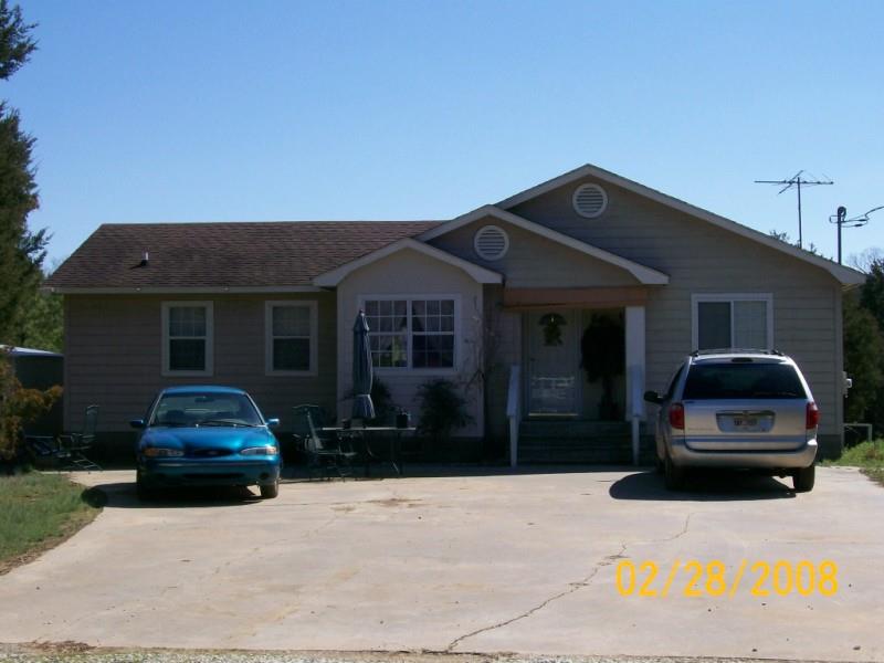
Loading Street View...
For this property only. Prepared by our title team and emailed to you.
An illustrative scenario from your assumptions, not an estimate for this property.
Profit as a percentage of the total cost of the deal, earned over the 180-day hold. Not a yearly rate.
Example values, not estimates for this property.
Maximum bid for this scenario
$165,183
The highest bid that still returns 20% on all-in cost under the assumptions below. Higher repairs or a higher target lower it.
Demonstration values, not typical costs or this property's. Subscribers set their own in the full worksheet.
914285 NOTICE OF SALE UNDER POWER GEORGIA, ELBERT COUNTY By virtue of a Power of Sale contained in that certain Security Deed from Maria T. Hardy nka Maria T. Prince to Countrywide Home Loans Inc., dated February 14, 2003, recorded February 27, 2003, in Book 335, Page 598-610, Elbert County, Georgia Records, said Security Deed having been given to secure a Note of even date in the original principal amount of Ninety-One Thousand Eight Hundred and 00/100 dollars ($91,800.00), with interest thereon as provided for therein, said Security Deed having been last sold, assigned and transferred to Rocket Mortgage, LLC s/b/m Nationstar Mortgage LLC, there will be sold at public outcry to the highest bidder for cash at the Elbert County Courthouse, within the legal hours of sale on the first Tuesday in August, 2026, all property described in said Security Deed including but not limited to the following described property: All that tract or parcel of land lying and being in land lot 195 G.M. District, Elbert Eounty, Georgia, containing 1.50 acres, more or less, according to survey for William H. Prince Jr. and Maria T. Hardy by Piedmont Surveying Company, dated February 2, 1995 and being more particularly described as follows: Beginning at the southwest corner of 30' ingress-egress easement and the centerline of County Road No. 244, .80 mile from center of County Road 304, running thence along reference line the following course and distances to the point of beginning; running thence along centerline of County Road No. 244 north 58 degrees 30 minutes 00 seconds, east 30.70 feet; leaving road running thence south 43 degrees 43 minutes 09 seconds east 61.07 feet; thence south 39 degrees 49 minutes 55 seconds east 134.69 feet; thence south 42 degrees 31 minutes 26 seconds east 88.56 feet; thence south 52 degrees 11 minutes 58 seconds east 128.88 feet; thence south 62 degrees 34 minutes 49 seconds east 80.05 feet; thence south 66 degrees 42 minutes 17 seconds east 75.27 feet; thence south 70 degrees 07 minutes 19 seconds east 216.97 feet; thence south 66 degrees 15 minutes 11 seconds east 74.23 feet; thence south 52 degrees 41 minutes 37 seconds east 110.53 feet; thence south 42 degrees 18 minutes 20 seconds east 95.25 feet; to the intersection of a 30 foot ingress-egress easement and described property, running thence along property line south 76 degrees 23 minutes 41 seconds east 109.92 feet to an iron pin corner; thence south 14 degrees 33 minutes 08 seconds east 215.40 feet to and iron pin corner, thence north 76 degrees 36 minutes 01 seconds west 343.71 feet; thence north 14 degrees 28 minutes 19 seconds west 216.04 feet; thence south 76 degrees 23 minutes 41 seconds east 234.10 feet to the point of beginning. 30 FOOT INGRESS-EGRESS EASEMENT: Beginning a southwest corner of 30' ingress-egress easement and centerline of County Road No. 244, .80 mile from center of County Road 304; running thence along centerline of County Road No, 244 north 58 degrees 30 minutes 00 seconds east 30.70 feet; leaving road running thence south 43 degrees 43 minutes 09 seconds east 61.07 feet; thence south 39 degrees 49 minutes 55 seconds east 134.69 feet; thence south 42 degrees 31 minutes 26 seconds east 88.56 feet; thence south 52 degrees 11 minutes 58 seconds east 128.88 feet; thence south 62 degrees 34 minutes 49 seconds east 80.05 feet; thence south 66 degrees 42 minutes 17 seconds east 75.27 feet; thence south 70 degrees 07 minutes 19 seconds east 216.97 feet; thence south 66 degrees 15 minutes 11 seconds east 74.23 feet; thence south 52 degrees 41 minutes 37 seconds east 110.53 feet; south 43 degrees 18 minutes 20 seconds east 95.25 feet; thence along property line north 76 degrees 23 minutes 41 seconds west 54.95 feet; leaving property running thence north 43 degrees 18 minutes 20 seconds west 46.75 feet; thence north 52 degrees 41 minutes 37 seconds west 104.50 feet; thence north 66 degrees 15 minutes 11 seconds east 69.65 feet; thence north 70 degrees 07 minutes 19 seconds west 216.85 feet; thence north 66 degrees 42 minutes 17 seconds west 77.24 feet; thence north 62 degrees 34 minutes 49 seconds west 83.85 feet; thence north 52 degrees 11 minutes 58 seconds west 134.14 feet; thence north 42 degrees 31 minutes 26 seconds west 91.80 feet; thence north 39 degrees 49 minutes 55 seconds west 134.37 feet; thence north 43 degrees 43 minutes 09 seconds west 66.55 feet to the point of beginning. Property bounded on east by U.S. Government, south by now or formerly H.R. Prince, west and north by W.H. Prince Sr. Said legal description being controlling, however the property is more commonly known as 2258 Tim Prince Drive, Elberton, GA 30635. The indebtedness secured by said Security Deed has been and is hereby declared due because of default under the terms of said Security Deed. The indebtedness remaining in default, this sale will be made for the purpose of paying the same, all expenses of the sale, including attorneys' fees (notice to collect same having been given) and all other payments provided for under the terms of the Security Deed. Said property will be sold on an “as-is” basis without any representation, warranty or recourse against the above-named or the undersigned. The sale will also be subject to the following items which may affect the title: any outstanding ad valorem taxes (including taxes which are a lien, whether or not now due and payable); the right of redemption of any taxing authority; matters which would be disclosed by an accurate survey or by an inspection of the property; all zoning ordinances; assessments; liens; encumbrances; restrictions; covenants, and any other matters of record superior to said Security Deed. To the best of the knowledge and belief of the undersigned, the owner and party in possession of the property is Maria T. Hardy nka Maria T. Prince, or tenants(s). The sale will be conducted subject (1) to confirmation that the sale is not prohibited under the U.S. Bankruptcy Code (2) to final confirmation and audit of the status of the loan with the holder of the Security Deed, and (3) purchaser's tendering to Rubin Lublin, LLC, anti-money laundering information as required pursuant to the FinCEN Real Estate Report Rule. Failure to provide information, could result in rescission of the sale. The entity having full authority to negotiate, amend and modify all terms of the loan (although not required by law to do so) is: Rocket Mortgage, LLC sbm Nationstar Mortgage LLC, Loss Mitigation Dept., 8950 Cypress Waters Blvd, Coppell, TX 75019, Telephone Number: 888-480-2432/833-685-8589. Nothing in O.C.G.A. Section 44-14-162.2 shall be construed to require a secured creditor to negotiate, amend, or modify the terms of the mortgage instrument. Rocket Mortgage, LLC S/B/M Nationstar Mortgage LLC as Attorney in Fact for Maria T. Hardy nka Maria T. Prince The below law firm may be held to be acting as a debt collector, under federal law. If so, any information obtained will be used for that purpose. Attorney Contact: RUBIN LUBLIN, LLC 3145 Avalon Ridge Place, Suite 100 Peachtree Corners, GA 30071 Telephone Number: 877-813-0992 Case No. NAT-16-00696-3 rlselaw.com/property-listing 7-8,15,22,29
Recorded from 3 sources. First recorded June 25, 2026. Record as of October 24, 2026. About this data & licence
Subscribers see this record 14 days earlier, plus the owner of record and mailing address.
Title Reports need only a free account.