Public record · 14-day delayAbout our data
957 Us Highway 82, Georgetown, GA 39854-4605 · Quitman County
Sold · Auction held October 6, 2026
Subscribers get the latest updates, owner information including mailing address, tax card links, and the option to create instant property alerts.
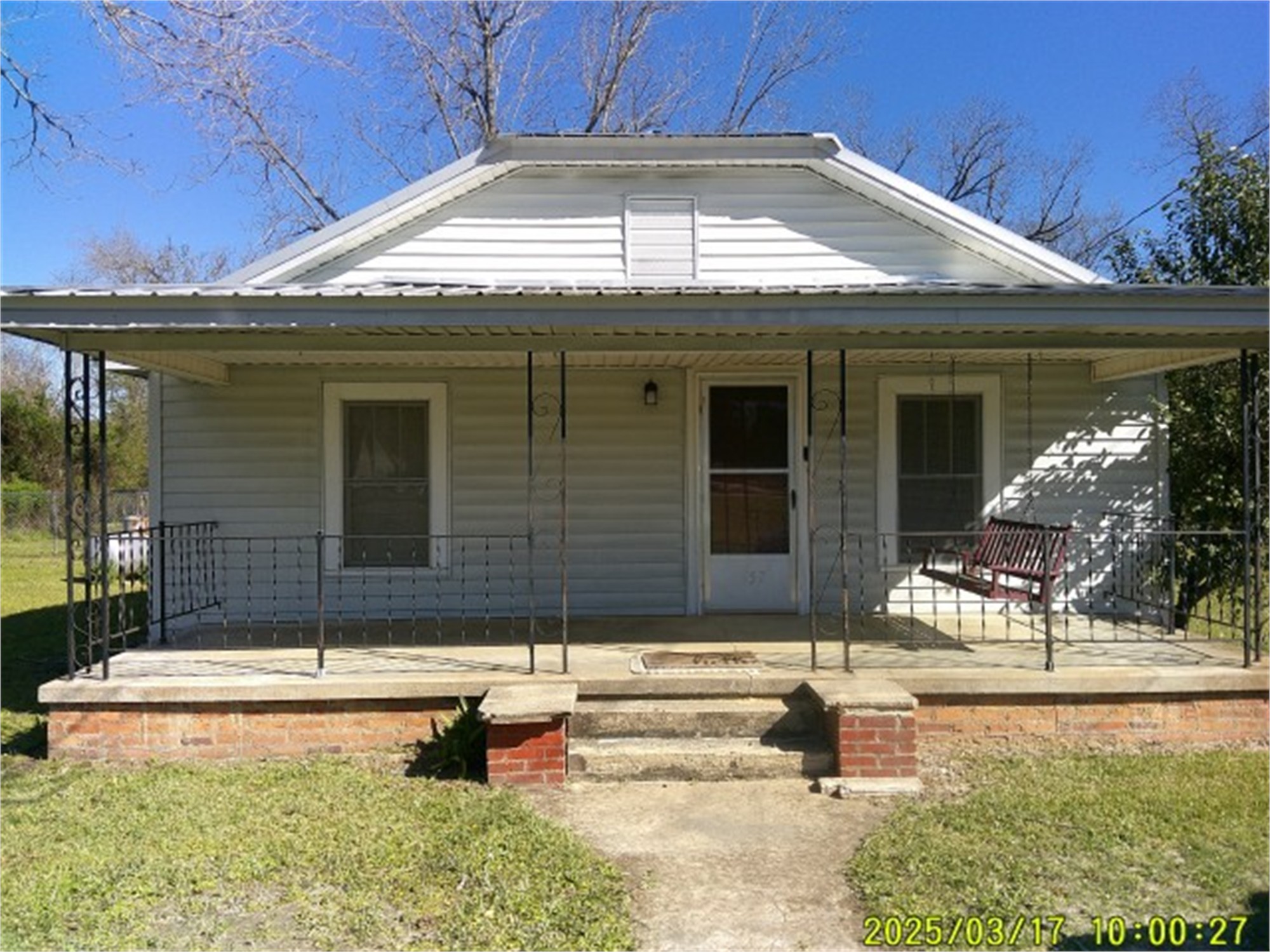
Loading Street View...
For this property only. Prepared by our title team and emailed to you.
An illustrative scenario from your assumptions, not an estimate for this property.
Profit as a percentage of the total cost of the deal, earned over the 180-day hold. Not a yearly rate.
Example values, not estimates for this property.
Maximum bid for this scenario
$165,183
The highest bid that still returns 20% on all-in cost under the assumptions below. Higher repairs or a higher target lower it.
Demonstration values, not typical costs or this property's. Subscribers set their own in the full worksheet.
NOTICE OF SALE UNDER POWER STATE OF GEORGIA, COUNTY OF QUITMAN By virtue of a Power of Sale contained in that certain Security Deed from Nora Nell King and Freddie Jenkins to Mortgage Electronic Registration Systems, Inc., as nominee for InterLinc Mortgage Services, LLC, dated October 26, 2023 and recorded on October 30, 2023 in Deed Book 134, Page 31, in the Office of the Clerk of Superior Court of Quitman County, Georgia, said Security Deed having been given to secure a Note of even date, in the original principal amount of Seventy-Four Thousand Six Hundred Twenty-Three and 00/100 dollars ($74,623.00) with interest thereon as provided therein, as last transferred to Planet Home Lending, LLC by assignment recorded at Book 139, Page 666, aforesaid records, will be sold at public outcry to the highest bidder for cash before the courthouse door of Quitman County, Georgia, or at such place as has or may be lawfully designated as an alternative location, within the legal hours of sale on the first Tuesday in October, 2026, all property described in said Security Deed including but not limited to the following described property: STARTING AT A CONCRETE RIGHT-OF-WAY MARKER ON THE NORTH RIGHT-OF-WAY OF US HIGHWAY NO. 82 AT STATION DESIGNATION 1 973.053 THENCE NORTH 89 DEGREES 41 MINUTES 35 SECONDS WEST A DISTANCE OF 103.15 FEET TO A CONCRETE RIGHT-OF-WAY MARKER AT STATION 1 941.629 AND THE POINT OF BEGINNING; THENCE NORTH 84 DEGREES 08 MINUTES 42 SECONDS WEST A DISTANCE OF 71.17 FEET TO A CONCRETE RIGHT-OF-WAY MARKER AT STATION 1 920.0; THENCE NORTH 89 DEGREES 56 MINUTES 13 SECONDS WEST A DISTANCE OF 31.82FEET TO AN IRON PIN; THENCE NORTH 01 DEGREES 18 MINUTES 19 SECONDS EAST A DISTANCE OF 222.71 FEET TO A REFERENCE IRON PIN; THENCE NORTH 01 DEGREES 18 MINUTES 19 SECONDS EAST A DISTANCE OF 2.08 FEET; THENCE SOUTH 89 DEGREES 41 MINUTES 35 SECONDS EAST A DISTANCE OF 102.78 FEET TO AN IRON PIN; THENCE SOUTH 01 DEGREES 18 MINUTES 19 SECONDS WEST A DISTANCE OF 231.54 FEET TO THE POINT OF BEGINNING AND CONTAINING 0.536 ACRES. BEING FURTHER IDENTIFIED AS HAVING SUCH SHAPE, SIZE, METES AND BOUNDS, COURSES AND DISTANCES AS ARE SHOWN UPON THAT PLAT OF SURVEY PREPARED BY RICHARD J. SHORTER, GEORGIA REGISTERED LAND SURVEYOR NO. 2476 FOR JOHNNY WILSON DATED THE 5TH DAY OF AUGUST, 2008 AND RECORDED IN PLAT BOOK/CABINET A67 AT PAGE 5B IN THE OFFICE OF THE CLERK OF SUPERIOR COURT FOR QUITMAN COUNTY, GEORGIA. REFERENCE IS HEREBY MADE TO SAID PLAT AND INCORPORATED HEREIN FOR THE PURPOSE OF A MORE PARTICULAR AND ACCURATE DESCRIPTION OF THE PROPERTY HEREIN CONVEYED. THIS BEING THE SAME PROPERTY AS DESCRIBED IN THAT CERTAIN WARRANTY DEED FROM NINA P. CORLEE TO LEONARD F. CORLEE DATED APRIL, 1999 AND RECORDED THE 13TH DAY OF APRIL, 1999 IN DEED BOOK 78 AT PAGE 748 IN THE OFFICE OF THE CLERK OF SUPERIOR COURT OF QUITMAN COUNTY, GEORGIA. LEONARD F. CORLEE WAS THE ONLY CHILD OF FOY N. CORLEE AND NINA P. CORLEE. SUBJECT TO RESTRICTIONS, EASEMENTS AND RIGHTS OF WAY, VISIBLE AND OF RECORD, IF ANY. Said property may more commonly be known as 957 US Highway 82, Georgetown, GA 39854. The debt secured by said Security Deed has been and is hereby declared due because of, among other possible events of default, non-payment of the monthly installments on said loan. The debt remaining in default, this sale will be made for the purpose of paying the same and all expenses of this sale, including attorneys fees (notice of intent to collect attorneys fees having been given). The individual or entity that has full authority to negotiate, amend and modify all terms of the loan is Planet Home Lending, LLC, 321 Research Parkway, Suite 303, Meriden CT 06450, (203) 303-5283. Said property will be sold on an as-is basis without any representation, warranty or recourse against the above-named or the undersigned. The sale will also be subject to the following items which may affect the title: a) zoning ordinances; b) matters which would be disclosed by an accurate survey or by an inspection of the property; c) any outstanding ad valorem taxes, including taxes, which constitute liens upon said property whether or not now due and payable; d) special assessments; e) the right of redemption of any taxing authority; f) all outstanding bills for public utilities which constitute liens upon said property; g) all restrictive covenants, easements, rights-of-way and any other matters of record superior to said Security Deed. To the best of the knowledge and belief of the undersigned, the owners and party in possession of the property are _ Freddie Jenkins, Nora Nell King and or tenant(s). The sale will be conducted subject to 1) confirmation that the sale is not prohibited under the U.S. Bankruptcy code and 2) final confirmation and audit of the status of the loan with the holder of the Security Deed. Planet Home Lending, LLC as Attorney-in-Fact for Nora Nell King and Freddie Jenkins
Recorded from 3 sources. First recorded August 7, 2026. Record as of October 23, 2026. About this data & licence
Subscribers see this record 14 days earlier, plus the owner of record and mailing address.
Title Reports need only a free account.