Public record · 14-day delayAbout our data
20 Chateau Dr Se, Rome, GA 30161-7206 · Floyd County
Awaiting outcome · Sale date November 3, 2026 · result pending
Subscribers get the latest updates, owner information including mailing address, tax card links, and the option to create instant property alerts.
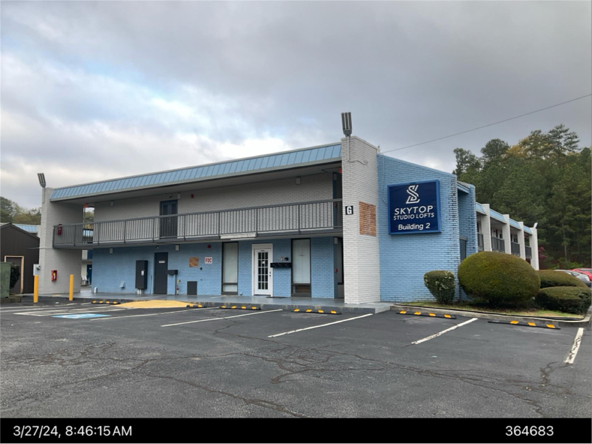
Loading Street View...
For this property only. Prepared by our title team and emailed to you.
An illustrative scenario from your assumptions, not an estimate for this property.
Profit as a percentage of the total cost of the deal, earned over the 180-day hold. Not a yearly rate.
Example values, not estimates for this property.
Maximum bid for this scenario
$165,183
The highest bid that still returns 20% on all-in cost under the assumptions below. Higher repairs or a higher target lower it.
Demonstration values, not typical costs or this property's. Subscribers set their own in the full worksheet.
NOTICE OF SALE UNDER POWER FLOYD COUNTY By virtue of the power of sale contained in that certain Multifamily Deed to Secure Debt, Assignment of Leases and Rents, Security Agreement and Fixture Filing (Security Deed) from 5TH STREET HILLTOP, LLC, a Georgia limited liability company (Borrower) to LIMA ONE CAPITAL, LLC, a Georgia limited liability company (Lender), dated July 7, 2023, recorded on July 11, 2023 in Deed Book 2804, Pages 20-47 of the Office of the Clerk of Superior Court of Floyd County, Georgia (the Security Deed), which secured Borrowers Multifamily Note dated July 7, 2023 in the principal amount of Fourteen Million, Five Hundred Sixty Thousand and No/100 Dollars ($14,560,000.00) executed by Borrower in favor of Lender (together with any and all renewals, replacements, modifications, and extensions thereof, if any, the Note), which Security Deed and Note have been assigned to GHC ROME OWNER LLC, a Delaware limited liability company by Assignment of Multifamily Deed to Secure Debt, Assignment of Leases and Rents, Security Agreement and Fixture Filing dated October 2, 2026, the undersigned will sell at public outcry to the highest bidder for cash before the door of the County Courthouse in Floyd County, Georgia, on the first Tuesday in November 2026 (November 3, 2026), between the legal hours of sale, the property described as follows (the Property): See Exhibit A attached hereto and by this reference made a part hereof. The debt secured by the Security Deed has been and is hereby declared due and payable because of, among other possible events of default, the failure to make monthly payments under the Note when due. The debt remaining in default, this sale will be made for the purpose of paying the debt, including accrued interest, expenses of the sale, and attorneys fees, notice of intention to collect attorneys fees having been given in accordance with applicable law, as well as all other sums provided for under the Note and the Security Deed. The remaining proceeds, if any, shall be applied as provided by law. The Property will be sold as the property of Borrower. To the undersigned's best knowledge and information, Borrower is the party in possession of the Property. The Property will be sold as is, without express or implied warranties of any kind, subject to: all zoning ordinances; matters that would be disclosed by an accurate survey or an inspection of the Property; any outstanding taxes and governmental assessments, including unpaid real and personal property ad valorem taxes; all outstanding bills for public utilities that constitute liens upon the Property; all restrictive covenants, easements, rights-of-way, and assessments. This sale will be conducted subject to (i) confirmation that it is not prohibited by the United States Bankruptcy Code, and (ii) the provisions of O.C.G.A. ?9-13-172.1 that permit the rescission of judicial and non-judicial foreclosure sales in Georgia in certain circumstances. The undersigned will execute a deed to the purchaser as provided in the Security Deed. The individual or entity with full authority to negotiate, amend, and modify the terms of the Note and the Security Deed is Adam Feldman, GoodHomes Communities, 36 W. 25th St., 15th Floor, New York, NY 10010, 917-613-0145. However, such individual or entity is not required by law to negotiate, amend, or modify the terms of the Note or the Security Deed. By: GHC ROME OWNER LLC, c/o Robert R. Stubbs, Esq. (GA Bar No. 689750), Parker Poe Adams & Bernstein LLP, 1075 Peachtree Street NE, Suite 1500, Atlanta, Georgia 30309; bobstubbs@parkerpoe.com; (404) 665-1250. THIS LAW FIRM MAY BE ATTEMPTING TO COLLECT A DEBT. ANY INFORMATION OBTAINED WILL BE USED FOR THAT PURPOSE. EXHIBIT ?A? TRACT A-1 ALL THAT PROPERTY LYING, BEING AND SITUATED IN LAND LOT 326, 23RD DISTRICT, 3RD SECTION, FLOYD COUNTY, SECOND WARD OF THE CITY OF ROME, GEORGIA AND BEING TRACT "A-1" ACCORDING TO A PLAT THEREOF RECORDED IN PLAT BOOK 34, PAGE 122 IN THE OFFICE OF THE CLERK OF SUPERIOR COURT, FLOYD COUNTY, GEORGIA AND BEING MORE PARTICULARLY DESCRIBED AS FOLLOWS: COMMENCING AT THE POINT WHERE THE SOUTH RIGHT OF WAY OF U.S. HIGHWAY 411-STATE ROUTE 20 (ALSO KNOWN AS THE ROME-CARTERSVILLE HIGHWAY - VARIABLE RIGHT OF WAY) INTERSECTS THE NORTHWEST RIGHT OF WAY OF CHATEAU DRIVE (FORMERLY KNOWN AS MCFALL LANE - 60 FOOT RIGHT OF WAY); THENCE RUNNING IN A SOUTHWESTERLY DIRECTION ALONG THE NORTHWESTERLY RIGHT OF WAY OF CHATEAU DRIVE 630.69' TO A REBAR FOUND; THENCE NORTH 57?56'48" WEST A DISTANCE OF 689.94' TO A 1/2" REBAR FOUND; THENCE NORTH 16?55'01" EAST A DISTANCE OF 132.43' TO A 1/2" REBAR FOUND, WHICH IS THE POINT OF BEGINNING. FROM THE POINT OF BEGINNING, THENCE NORTH 73?08'24" WEST A DISTANCE OF 298.92' TO A 1/2" REBAR FOUND; THENCE SOUTH 16?51'36" WEST A DISTANCE OF 15.03' TO A 1/2" REBAR FOUND; THENCE NORTH 72?57'56" WEST A DISTANCE OF 109.63' TO A 1/2" REBAR FOUND; THENCE NORTH 17?02'04" EAST A DISTANCE OF 20.00' TO A 1/2" REBAR FOUND; THENCE NORTH 72?57'56" WEST A DISTANCE OF 148.42' TO A 1/2" REBAR FOUND; THENCE NORTH 15?12'26" EAST A DISTANCE OF 583.39' TO A CONCRETE MARKER LOCATED ON THE SOUTH RIGHT OF WAY OF U.S. HIGHWAY 411-STATE ROUTE 20; THENCE RUNNING ALONG SAID RIGHT OF WAY, ALONG THE ARC OF A CURVE TO THE RIGHT HAVING A RADIUS OF 1337.61' (SAID ARC BEING SUBTENDED BY A CHORD BEARING SOUTH 67?38'15" EAST, A DISTANCE OF 313.92') AN ARC DISTANCE OF 314.65' TO A CONCRETE MARKER; THENCE CONTINUING ALONG SAID RIGHT OF WAY THE FOLLOWING COURSES AND DISTANCES: SOUTH 35?05'39" EAST A DISTANCE OF 163.00' TO A CONCRETE MARKER; THENCE SOUTH 61?15'23" EAST A DISTANCE OF 100.37' TO A CONCRETE MARKER; THENCE NORTH 83?00'35" EAST A DISTANCE OF 38.40' TO A 1/2" OPEN TOP PIPE; THENCE LEAVING THE SOUTH RIGHT OF WAY OF U.S. HIGHWAY 411-STATE ROUTE 20, SOUTH 16?55'01" WEST A DISTANCE OF 453.21' TO A 1/2" REBAR FOUND, WHICH IS THE POINT OF BEGINNING. SAID PROPERTY CONTAINS AN AREA OF 6.930 ACRES AND IS SHOWN AS TRACT A-1 ON AN ALTA/NSPS SURVEY FOR "5TH STREET HILLTOP, LLC, OLD REPUBLIC TITLE INSURANCE COMPANY AND LIMA ONE CAPITAL, LLC, DATED APRIL 9, 2018 AND LAST REVISED JULY 5, 2023, PREPARED BY FLOYD-HORNE LAND SURVEYORS, BILLY L. FLOYD, GEORGIA REGISTERED LAND SURVEYOR #3078. TRACT A-2 ALL THAT PROPERTY LYING, BEING AND SITUATED IN LAND LOTS 326, 354 AND 355, 23RD DISTRICT, 3RD SECTION, FLOYD COUNTY, SECOND WARD OF THE CITY OF ROME, GEORGIA AND BEING A PART OF TRACT 1 ACCORDING TO A PLAT THEREOF RECORDED IN PLAT BOOK 13, PAGE 75 IN THE OFFICE OF THE CLERK OF SUPERIOR COURT OF FLOYD COUNTY, GEORGIA AND ALSO BEING TRACT "A-2" ACCORDING TO A PLAT THEREOF RECORDED IN PLAT BOOK 34, PAGE 164 AND BEING MORE PARTICULARLY DESCRIBED AS FOLLOWS: COMMENCING AT THE POINT WHERE THE SOUTH RIGHT OF WAY OF U.S. HIGHWAY 411-STATE ROUTE 20 (ALSO KNOWN AS THE ROME-CARTERSVILLE HIGHWAY-VARIABLE RIGHT OF WAY) INTERSECTS THE NORTHWEST RIGHT OF WAY OF CHATEAU DRIVE (FORMERLY KNOWN AS MCFALL LANE - 60 FOOT RIGHT OF WAY); THENCE RUNNING IN A SOUTHWESTERLY DIRECTION ALONG THE NORTHWESTERLY RIGHT OF WAY OF CHATEAU DRIVE 630.69' TO A 1/2" REBAR FOUND ON THE NORTHWEST RIGHT OF WAY OF CHATEAU DRIVE, WHICH IS THE POINT OF BEGINNING. FROM THE POINT OF BEGINNING, THENCE ALONG THE NORTHWESTERLY RIGHT OF WAY OF CHATEAU DRIVE, SOUTH 32?47'39" WEST A DISTANCE OF 199.83' TO A 1/2" REBAR FOUND; THENCE LEAVING THE NORTHWESTERLY RIGHT OF WAY OF CHATEAU DRIVE, NORTH 59?32'39" WEST A DISTANCE OF 629.05' TO A 1/2" REBAR FOUND; THENCE NORTH 86?03'26" WEST A DISTANCE OF 314.33' TO A 1/2" REBAR FOUND; THENCE NORTH 06?33'04" WEST A DISTANCE OF 230.22' TO A 1/2" REBAR FOUND; THENCE NORTH 88?11'46" WEST A DISTANCE OF 156.25' TO A 1/2" REBAR FOUND; THENCE NORTH 15?12'26" EAST A DISTANCE OF 262.98' TO A 1/2" REBAR FOUND; THENCE SOUTH 72?57'56" EAST A DISTANCE OF 148.42' TO A 1/2" REBAR FOUND; THENCE SOUTH 17?02'04"' WEST A DISTANCE OF 20.00' TO A 1/2" REBAR FOUND; THENCE SOUTH 72?57'56" EAST A DISTANCE OF 109.63' TO A 1/2" REBAR FOUND; THENCE NORTH 16?51'36" EAST A DISTANCE OF 15.03' TO A 1/2" REBAR FOUND; THENCE SOUTH 73?08'24" EAST A DISTANCE OF 298.92' TO A 1/2" REBAR FOUND; THENCE SOUTH 16?55'01" WEST A DISTANCE OF 132.43' TO A 3/4" ROD; THENCE SOUTH 57?56'48"' EAST A DISTANCE OF 112.03' TO A 1" OPEN TOP PIPE; THENCE SOUTH 31?29'06" WEST A DISTANCE OF 125.35' TO A 1/2" REBAR FOUND; THENCE SOUTH 59?25'56" EAST A DISTANCE OF 421.39' TO A 1/2" REBAR FOUND; THENCE NORTH 31?14'59" EAST A DISTANCE OF 114.43' TO A 1/2" REBAR FOUND; THENCE SOUTH 57?56'48" EAST A DISTANCE OF 157.02' TO A 1/2" REBAR FOUND LOCATED ON THE NORTHWESTERLY RIGHT OF WAY OF CHATEAU DRIVE, WHICH IS THE POINT OF BEGINNING. SAID PROPERTY CONTAINS AN AREA OF 6.269 ACRES AND IS SHOWN AS TRACT A-2 ON AN ALTA/NSPS SURVEY FOR "5TH STREET HILLTOP, LLC, OLD REPUBLIC TITLE INSURANCE COMPANY AND LIMA ONE CAPITAL, LLC, DATED APRIL 9, 2018 AND LAST REVISED JULY 5, 2023, PREPARED BY FLOYD-HORNE LAND SURVEYORS, BILLY L. FLOYD, GEORGIA REGISTERED LAND SURVEYOR #3078. The address of the property is 20 Chateau Drive, SE, Rome. GA 30161 Tax Parcel Numbers: J15W 530 J15W 530A 10:9,16,23,30,2026
Recorded from 1 source. First recorded October 9, 2026. Record as of October 26, 2026. About this data & licence
Subscribers see this record 14 days earlier, plus the owner of record and mailing address.
Title Reports need only a free account.